
Thursday, December 31, 2009
Heavy Snow Part 1
Here is video from the heavy snow fall last night. These were some of the largest snow flakes that I have ever seen. Part two coming next year. I have a downtown party to rest up for tonight. Happy New Years, everyone! I'll be doing something special early next month.
Tuesday, December 29, 2009
Snow Storm Part 3
Part 3 of video from the snow storm on the night of the 27th and the aftermath the following morning. I was surprised by how well they had cleared the roads in just a few short hours. They were very slippery the night of the storm.
Monday, December 28, 2009
Snow Storm Part 2
Part two of the snow storm on 12/27/2009. I decided to go ahead and upload most of the footage I filmed tonight since it was too good to leave on my computer's hard drive. Most of part three will be filmed later today as this is a continuing event.
Snow Storm Part 1
This footage was shot entirely by rockystop123 during some of the worst parts of the snow storm last night. More snow is expected and I will be back out to film tomorrow morning. I will be uploading the footage I shot after it's all over.
Snow Fall Video From The 18th Through The 22nd
Here are some clips that were shot of the light snow fall from the 18th through the 22nd of December. The standar definition content was filmed by rockystop123.
More to come...
More to come...
Sunday, December 27, 2009
Snow Storm
Major snow storm happening right now. I just got back from filming a few hours ago. The roads are really bad. Everyone be careful out there!
Friday, December 25, 2009
Happy Holidays!
Here is video of my roommate's decorations. I helped with some of them.
Snow video coming soon! rockystop123 is contributing some video this time and I just need to wait until I can get the clips that he shot before I can start editing.
Snow video coming soon! rockystop123 is contributing some video this time and I just need to wait until I can get the clips that he shot before I can start editing.
Friday, December 18, 2009
Snow!
Snow is falling and accumulating outside as I type this. I just came in from filming few night shots and plan to head out some time tomorrow morning.
Saturday, December 12, 2009
High Wind Warning Video
This is video from the high wind warning we were under on the 9th. Damage was minimal and consisted of downed limbs, snapped telephone lines, and shredded billboard signs.
Tuesday, December 8, 2009
High Wind Warning For Tomorrow
Be careful while driving tomorrow and be ready for sporadic power outages.
I will likely be filming when it starts to get really bad.
...HIGH WIND WARNING IN EFFECT FROM 7 AM WEDNESDAY TO 1 AM EST
THURSDAY...
THE NATIONAL WEATHER SERVICE IN WILMINGTON HAS ISSUED A HIGH WIND
WARNING...WHICH IS IN EFFECT FROM 7 AM WEDNESDAY TO 1 AM EST
THURSDAY. THE HIGH WIND WATCH IS NO LONGER IN EFFECT.
*A DEEPENING LOW PRESSURE SYSTEM WILL MOVE NORTHEAST INTO THE
WESTERN GREAT LAKES BY WEDNESDAY MORNING. A STRONG COLD FRONT
WILL CROSS THE OHIO VALLEY ON WEDNESDAY. VERY STRONG WINDS WILL
OVERSPREAD THE AREA WEDNESDAY AND CONTINUE INTO WEDNESDAY
EVENING. SOUTHWEST TO WESTERLY WINDS WILL BE IN THE 30 MPH TO 40
MPH RANGE WITH WIND GUSTS NEAR 60 MPH POSSIBLE.
I will likely be filming when it starts to get really bad.
Monday, December 7, 2009
Pics From This Morning
Here are some cell phone pics taken of the road conditions earlier this morning by rockystop123. All the snow had melted by the time I had woken up, so I'm glad someone was thinking of me. :) I see now why there was an advisory for this.


More Snow
It snowed again this morning and from what I was told it actually covered the ground. I woke up in time to catch the last little bit a snow spurts which was not enough to film. By that time the snow on the ground had melted. Hopefully I can catch any snow fall that may occur later on this week.
Saturday, November 28, 2009
HD Video Of The First Snow Fall Of The Season
A portion of this video did not render properly during editing. Editing HD video is time consuming and it doesn't always do what you want it to do. In any case I hope it's still enjoyable. :)
Friday, November 27, 2009
First Snow
We got our first snow of the season this morning as eager shoppers pushed each other down to get the last of the mechanical hamsters. I got some incredible footage that I will start uploading tomorrow.
Sunday, November 8, 2009
Tropical Storm Ida
It looks like Hurricane Ida will be effecting the Gulf of Mexico soon, but will likely die down to a Tropical Storm by the time it reaches land according to the National Hurricane Center's five day forecast model.
Update November 8, 2009 10:00PM EDT: I may have spoken too soon. According to the latest models, Ida will effect US soil as a Hurricane, but is still likely to be a Tropical Storm by the time it makes landfall. The governor of Louisiana has declared a state of emergency and there is currently a Hurricane Watch extending from Grand Isle in Louisiana to Pascagoula Mississippi and a Hurricane Warning extending from Pascagoula Mississippi to Indian Pass in the Florida panhandle.
Update November 9, 2009 5:00PM EDT: Even though Ida has weakened to a Tropical Storm, Florida, Louisiana, Alabama, and Mississippi have all declared a state of emergency. The center of the storm looks like it may move over the coast of Alabama or even the far west side of the Florida panhandle. Tropical Storm warnings currently extend from Grand Isle in Louisiana all the way to the Aucilla River in Florida.
Update November 9, 2009 6:20PM EDT: Here is one of the current radar images from Mobile, Alabama.

This storm is being blasted by winds from the east so it's a bit lopsided. All the real convection is to the west which is why Louisiana has been experiencing some flooding.
Update November 9, 2009 11:45 PM EDT: A flash flood warning was just issued by The National Weather Service for parts of Alabama and Florida that has some valuable information attached to it:

Update November 10, 2009 1:30AM EDT: The center of circulation (if you can call it that) seems to be making it's way on to land at the moment. It's really hard to tell from the radar where the circulation actually is or even that this is a Tropical Storm.

This is made worse by the fact that information from tropical systems generally seem to be far and few between during the night hours. In any event, there's no doubt that the worst of the storm has made it's presence felt by now.
Update November 8, 2009 10:00PM EDT: I may have spoken too soon. According to the latest models, Ida will effect US soil as a Hurricane, but is still likely to be a Tropical Storm by the time it makes landfall. The governor of Louisiana has declared a state of emergency and there is currently a Hurricane Watch extending from Grand Isle in Louisiana to Pascagoula Mississippi and a Hurricane Warning extending from Pascagoula Mississippi to Indian Pass in the Florida panhandle.
Update November 9, 2009 5:00PM EDT: Even though Ida has weakened to a Tropical Storm, Florida, Louisiana, Alabama, and Mississippi have all declared a state of emergency. The center of the storm looks like it may move over the coast of Alabama or even the far west side of the Florida panhandle. Tropical Storm warnings currently extend from Grand Isle in Louisiana all the way to the Aucilla River in Florida.
Update November 9, 2009 6:20PM EDT: Here is one of the current radar images from Mobile, Alabama.

This storm is being blasted by winds from the east so it's a bit lopsided. All the real convection is to the west which is why Louisiana has been experiencing some flooding.
Update November 9, 2009 11:45 PM EDT: A flash flood warning was just issued by The National Weather Service for parts of Alabama and Florida that has some valuable information attached to it:
THE NATIONAL WEATHER SERVICE IN MOBILE HAS ISSUED A
* FLASH FLOOD WARNING FOR...
SOUTHEASTERN ESCAMBIA COUNTY IN NORTHWEST FLORIDA...
THIS INCLUDES THE CITY OF PENSACOLA...
SOUTHWESTERN SANTA ROSA COUNTY IN NORTHWEST FLORIDA...
SOUTHERN BALDWIN COUNTY IN SOUTHWEST ALABAMA...
EXTREME SOUTHEASTERN MOBILE COUNTY IN SOUTHWEST ALABAMA...
* UNTIL 130 AM CST
* AT 1023 PM CST...NATIONAL WEATHER SERVICE RADAR INDICATED A RAIN BAND
ASSOCIATED WITH TROPICAL STORM IDA...NEARLY STATIONARY OVER SOUTHERN PORTIONS
OF BALDWIN COUNTY ALABAMA...SOUTHERN ESCAMBIA COUNTY AND EXTREME
SOUTHWEST SANTA ROSA COUNTY IN FLORIDA. DOPPLER WEATHER RADAR TRENDS INDICATE THE
POTENTIAL OF HEAVY RAIN WILL CONTINUE INTO THE PREDAWN HOURS TUESDAY MORNING
OVER THE WARNED AREA.
* LOCATIONS IN THE WARNING INCLUDE BUT ARE NOT LIMITED TO BON
SECOUR...TURKEY BRANCH...SUMMERDALE...SILVERHILL...SEMINOLE...
ROBERTSDALE...POINT CLEAR...OAK...MOUTH OF WEEKS BAY...MONTROSE...
MIFLIN...MARLOW...MAGNOLIA SPRINGS...LILLIAN...HOUSTONVILLE...
FOLEY...FAIRHOPE...ELSANOR...ELBERTA...CLAY CITY...BATTLES WHARF...
WEST PENSACOLA...WARRINGTON...PENSACOLA REGIONAL A/P...PENSACOLA
NAVAL BASE...PACE...MYRTLE GROVE...GULF BREEZE...GOULDING...
GONZALEZ...FERRY PASS...ENSLEY...EAST PENSACOLA HEIGHTS...COTTAGE
HILL...CANTONMENT...BROWNSVILLE...BRENT...BEULAH AND BELLVIEW
DOPPLER WEATHER PRECIPITATION ESTIMATES SUGGEST THAT UPWARDS OF 2 TO
3 INCHES OF RAIN HAS ALREADY FALLEN OVER PORTIONS OF SOUTHERN
BALDWIN COUNTY...SOUTHEAST OF FOLEY SINCE 7 PM THIS EVENING. AMOUNTS
OF JUST UNDER 2 INCHES HAVE FALLEN OVER SOUTHERN ESCAMBIA COUNTY.
ADDITIONAL RAINFALL AMOUNTS OF 2 TO 4 INCHES ARE POSSIBLE IN THE
WARNED AREA THROUGH 130 AM TUESDAY MORNING.

Update November 10, 2009 1:30AM EDT: The center of circulation (if you can call it that) seems to be making it's way on to land at the moment. It's really hard to tell from the radar where the circulation actually is or even that this is a Tropical Storm.

This is made worse by the fact that information from tropical systems generally seem to be far and few between during the night hours. In any event, there's no doubt that the worst of the storm has made it's presence felt by now.
Monday, November 2, 2009
First Real Frost Of The Season
Those waking up this Monday morning in central Ohio will have some windshield scraping to do. It got below freezing last night and conditions were just right to introduce the first real frost of the season.
Saturday, October 31, 2009
Happy Halloween
Here's a treat for everyone that enjoys my videos! They will be shot in HD from now on. To see a test run of the new HD camera in action, click here. If you're computer is fast enough to play HD video, click the HD button on the bottom right side of the player. It looks great in full screen this way! I'll be looking forward to the first good snow of the season so that I can truly break it in.
Sunday, October 25, 2009
Fall Colors
I was out the other day and decided to bring my camera with me to film some fall leaf colors.
I saved this video in a much higher quality than I normally do. Let me know how it looks to you.
I saved this video in a much higher quality than I normally do. Let me know how it looks to you.
Friday, October 16, 2009
New Twitter Account
Weather Fan now has it's own twitter account. You can follow Weather Fan at weather_fan.
Tuesday, October 13, 2009
While We Wait
The thunderstorm season in Ohio is pretty much over. That means there's nothing much to do except for wait for the winter season to pick up. If it's anything like last season, we're going to be in for a long haul. In case you haven't noticed, Weather Fan now has a new logo.

In addition to to the upcoming winter storms, I should have a treat for everyone next year. It has always been my plan with this project to create a documentary of a full year of extreme weather in central Ohio. Once the year comes to a close, editing of the full length documentary with never before seen footage will commence.
Stay tuned!
Wednesday, September 23, 2009
Tuesday, September 22, 2009
Tuesday, September 8, 2009
Hurricane Fred
Tropical Storm Fred formed yesterday south-west of the Cape Verde Islands. It will be turning north, and although it could reach hurricane strength by tomorrow, it is not expected to impact any land masses.
Update September 9th, 2009 3:15AM
Fred became a hurricane last night.
Update September 10th, 2009 2:15PM
Fred briefly became a major hurricane yesterday and is now back down to a category two. It now holds the record for being the strongest hurricane in that part of the Atlantic. The current track path will eventually take it west, but by that time it is expected to be a tropical depression.
Wednesday, September 2, 2009
Tropical Storm Erika
Tropical Storm Erika seems to be on a path that will allow it to brush the northern Leeward Islands in the Antilles. Tropical Storm Watches have been issued for some of these islands.
Update September 5th, 2009 10:00AM
Erika weakened to a tropical depression last Thursday. Sorry for the late updates. Lots of things going on.
Update September 5th, 2009 10:00AM
Erika weakened to a tropical depression last Thursday. Sorry for the late updates. Lots of things going on.
Sunday, August 30, 2009
Torrential Downpour Video [Part 3]
The third and last video of the torrential downpour that prompted a Flash Flood Warning. Not that the dumpster is now floating and has been displaced.
Torrential Downpour Video [Part 2]
Here is part two of the torrential downpour that prompted a Flash Flood Warning yesterday.
Friday, August 28, 2009
Torrential Downpour Video [Part 1]
Here is part one of the edited video from the thunderstorms that produced heavy rain and prompted a Flash Flood Warning for Franklin County.
Part two will be up later on.
Part two will be up later on.
Severe Thunderstorm Warning For Delaware County
THE NATIONAL WEATHER SERVICE IN WILMINGTON HAS ISSUED A
* SEVERE THUNDERSTORM WARNING FOR...
SOUTHERN DELAWARE COUNTY IN CENTRAL OHIO...
* UNTIL 800 PM EDT.
* AT 731 PM EDT...NATIONAL WEATHER SERVICE DOPPLER RADAR INDICATED A
SEVERE THUNDERSTORM CAPABLE OF PRODUCING PENNY SIZE HAIL AND WINDS
TO 60 MPH. THIS STORM WAS LOCATED NEAR LEWIS CENTER...MOVING EAST
AT 15 MPH.
* LOCATIONS IMPACTED INCLUDE...
SUNBURY...
IN ADDITION...LEWIS CENTER...ALUM CREEK STATE PARK...INTERSTATE 71 AT
US ROUTE 36/STATE ROUTE 37...CENTER VILLAGE AND GALENA ARE NEAR THE
PATH OF THIS SEVERE THUNDERSTORM.

Severe Thunderstorm Warning For Northeastern Delaware And Northern Union Counties
THE NATIONAL WEATHER SERVICE IN WILMINGTON HAS ISSUED A
* SEVERE THUNDERSTORM WARNING FOR...
NORTHWESTERN DELAWARE COUNTY IN CENTRAL OHIO...
NORTHERN UNION COUNTY IN CENTRAL OHIO...
* UNTIL 645 PM EDT.
* AT 603 PM EDT...NATIONAL WEATHER SERVICE DOPPLER RADAR INDICATED A
SEVERE THUNDERSTORM CAPABLE OF PRODUCING PENNY SIZE HAIL AND WINDS
TO 60 MPH. THIS STORM WAS LOCATED NEAR SOMERSVILLE...MOVING EAST AT
20 MPH.
* LOCATIONS IMPACTED INCLUDE...
RICHWOOD...
IN ADDITION...SOMERSVILLE...PHARISBURG...ESSEX...MAGNETIC SPRINGS...
STATE ROUTE 229 AT US ROUTE 23...DELAWARE STATE PARK AND RADNOR ARE
NEAR THE PATH OF THIS SEVERE THUNDERSTORM.

Severe Thunderstorm Warning For Northwest Union And SouthEastern Hardin Counties
THE NATIONAL WEATHER SERVICE IN WILMINGTON HAS ISSUED A
* SEVERE THUNDERSTORM WARNING FOR...
NORTHWESTERN UNION COUNTY IN CENTRAL OHIO...
SOUTHEASTERN HARDIN COUNTY IN WEST CENTRAL OHIO...
* UNTIL 545 PM EDT.
* AT 522 PM EDT...NATIONAL WEATHER SERVICE DOPPLER RADAR INDICATED A
SEVERE THUNDERSTORM CAPABLE OF PRODUCING PENNY SIZE HAIL AND WINDS
TO 60 MPH. THIS STORM WAS LOCATED NEAR BYHALIA...MOVING NORTHEAST
AT 15 MPH.
* THE SEVERE THUNDERSTORM WILL AFFECT MAINLY RURAL AREAS OF
NORTHWESTERN UNION AND SOUTHEASTERN HARDIN COUNTIES...INCLUDING
ESSEX.

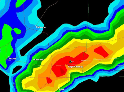
Flash Flood Warning For Southern Franklin County
THE NATIONAL WEATHER SERVICE IN WILMINGTON HAS ISSUED A
* FLASH FLOOD WARNING FOR...
SOUTHERN FRANKLIN COUNTY IN CENTRAL OHIO...
* UNTIL 615 PM EDT.
* AT 342 PM EDT...NATIONAL WEATHER SERVICE DOPPLER RADAR INDICATED
THAT THUNDERSTORMS HAD PRODUCED HEAVY RAINFALL ACROSS THE WARNED
AREA. RADAR ESTIMATED THAT BETWEEN 3 TO 4 INCHES OF RAIN HAD
FALLEN FROM NEAR GROVE CITY TO AROUND WHITEHALL SINCE 1 PM.
* HEAVY RAIN CONTINUES TO FALL ACROSS THE WARNED AREA WITH ANOTHER
1 TO 2 INCHES POSSIBLE THROUGH 530 PM EDT. RUNOFF FROM THIS
EXCESSIVE RAINFALL WILL CAUSE FLASH FLOODING TO OCCUR.
SOME LOCATIONS THAT MAY EXPERIENCE FLOODING INCLUDE...BEXLEY...
COLUMBUS...GAHANNA...GROVE CITY...REYNOLDSBURG AND GROVEPORT.

I wouldn't doubt that there is localized flooding occurring right now. I was out filming earlier and there's been very few breaks in between torrential down pours. While I didn't see any major flooding while I was out driving just a few minutes ago, the sides of the roads were so entrenched in water that they were very hard to drive through. Expect video later.
Wednesday, August 26, 2009
Tropical Storm Danny
It looks like this storm could potentially impact the north-east coastline. If it does, it will be no stronger than a category 1 and will likely be moving pretty darn fast.
Tuesday, August 25, 2009
Another NASA Shuttle Launch Scrubbed By Weather
"This launch attempt has been scrubbed due to weather. Conditions just did not improve with enough time to continue the countdown. The launch team is setting up for a 24-hour scrub turnaround.
"Well, C.J., the vehicle and operations were cooperating, but weather unfortunately did not," Launch Director Pete Nickolenko told Discovery Commander Rick "C.J." Sturckow.
Launch is scheduled for 1:10 a.m. Wednesday."
Check out NASA's STS-128 Launch Blog for more details and updates.
"Well, C.J., the vehicle and operations were cooperating, but weather unfortunately did not," Launch Director Pete Nickolenko told Discovery Commander Rick "C.J." Sturckow.
Launch is scheduled for 1:10 a.m. Wednesday."
Check out NASA's STS-128 Launch Blog for more details and updates.
Thursday, August 20, 2009
More Tornado Warnings
I was woken up again today by the sound of my weather radio screaming at me. Again there were tornado warnings for neighboring counties, this time to the south. This is what the radar looked like earlier.

Not much happening here otherwise. It looks like a storm may have came through while I was asleep. Our back patio is littered with tree leaves and branches. I can't be sure as of yet. It could have just been windy, and then rained.

Not much happening here otherwise. It looks like a storm may have came through while I was asleep. Our back patio is littered with tree leaves and branches. I can't be sure as of yet. It could have just been windy, and then rained.
Wednesday, August 19, 2009
Flash Flood Warning For Marion And Morrow
A Flash Flood Warning has been issued for Marion and Morrow Counties until 2AM EDT.

It looks like a few small cells have popped up in Franklin County and I'm debating on whether they're worth driving down the road for.

It looks like a few small cells have popped up in Franklin County and I'm debating on whether they're worth driving down the road for.
Rude Awakening
I woke up not too long ago to the weather radio screaming at me and this radar image.

Those red boxes are tornado warnings and the yellow box is a severe thunderstorm warning. No wonder there was a tornado warning with two air masses colliding like that. As per the norm lately, most of the storm activity has moved around Franklin County, but I was able to film a few lightning bolts down the street. I will be uploading them later when I have some free time.

Those red boxes are tornado warnings and the yellow box is a severe thunderstorm warning. No wonder there was a tornado warning with two air masses colliding like that. As per the norm lately, most of the storm activity has moved around Franklin County, but I was able to film a few lightning bolts down the street. I will be uploading them later when I have some free time.
Monday, August 17, 2009
Severe Thunderstorm Bust
A Severe Thunderstorm Warning was issued for a portion of Franklin and neighboring counties earlier. Due to the local radar being out, I did not travel far to try to catch a glimpse of this storm. By the time the radar came back on, the storm seemed to have weakened in to nothing but a rain cloud which is heading our way at this moment.
Sunday, August 16, 2009
Tropical Storm Claudette
Tropical Storm Claudette is will be making landfall on the Florida panhandle sometime tonight. It seems like this storm popped up out of nowhere today. I woke up and there it was; close to Florida.

Update August 17, 2009 1:30AM
Tropical Storm Claudette, with winds of 50MPH, is currently making landfall just west of Deston.


Update August 17, 2009 1:30AM
Tropical Storm Claudette, with winds of 50MPH, is currently making landfall just west of Deston.

Saturday, August 15, 2009
Hurricane Bill
We now have Tropical Storm Bill which is trailing Ana.
Update August 17, 2009 5:15AM EST.
Bill is now a Hurricane with winds of 75MPH. It is still 3 or 4 days away from even coming close to land. However, it is expected to intensify to a major hurricane in by that time and the long term path remains uncertain.
Update August 18, 2009 9:00PM EST.
Bill is now a major hurricane with winds of 125mph.
It will be Sunday before it impacts the north eastern part of the United States and possibly Canada.
Update August 22, 2009 12:30AM EST.
Bermuda is currently feeling the effects of hurricane Bill and the island is currently in the tropical storm wind field.
Bill has weekend to a category 2 hurricane since my last update.
Update August 24, 2009 1:30AM EST.
Bill has made landfall in Newfoundland Canada as a category 1 hurricane. Bill has caused minor damage in Canada throughout the day.
Update August 24, 2009 9:30AM EST.
Bill has become extratropical.
Tropical Storm Ana
The first storm of the Atlantic hurricane season is here. Ana is currently about 3 days away from the Leeward Islands with winds of 40MPH.
Update August 16, 2009
Ana is now a tropical depression.
Update August 16, 2009
Ana is now a tropical depression.
Tuesday, August 11, 2009
Waiting
Ohio has seen plenty of strong thunderstorm activity recently, but all the storms seem to go around Columbus. Some near Cleveland are still without power and cleaning up fallen trees. Podcaster and coder Chris Miller took this photograph six houses down from his home.
Friday, August 7, 2009
Tropical Storm Felicia
I usually don't track Pacific hurricanes, but this one is heading for Hawaii which is part of the United States. Right now, the hurricane is a category 4 but it is expected to weaken significantly to a tropical storm or depression before reaching the island. This does not mean that this storm will not be dangerous, however, as there could still be the threat of flooding.
Update August 09, 2009
Felicia is now a tropical storm and is expected to reach the islands by Tuesday morning.
Update August 11, 2009
Felicia has been downgraded to a tropical depression.
Update August 09, 2009
Felicia is now a tropical storm and is expected to reach the islands by Tuesday morning.
Update August 11, 2009
Felicia has been downgraded to a tropical depression.
Wednesday, August 5, 2009
Footage From Yesterday Morning
Thunderstorms were rolling through the area yesterday morning so went out with my camera and filmed this. I got a couple of good lightning bolts but the majority of the action was too far away and not severe enough to chase.
Monday, August 3, 2009
New Blog Feed!
Get updates from this blog via RSS! You can click here or see the link at the bottom of the side panel.
Friday, July 10, 2009
Saturday, July 4, 2009
5 Things NASA Scientists Are Trying To Figure Out About Hurricanes
JPL scientist Bjorn Lambrigtsen goes on hurricane watch every June. He is part of a large effort to track hurricanes and understand what powers them. Lambrigtsen specializes in the field of microwave instruments, which fly aboard research planes and spacecraft, penetrating through thick clouds to see the heart of a hurricane. While scientists are adept at predicting where these powerful storms will hit land, there are crucial aspects they still need to wrench from these potentially killer storms.
Read Full Article At NASA.GOV
Read Full Article At NASA.GOV
Saturday, June 27, 2009
GOES-O
NASA's new meteorological satellite has been launched and is expected to begin operating at the end of the year.
Click here to follow NASA's GOES-O launch blog.
Click here to follow NASA's GOES-O launch blog.
Friday, June 26, 2009
Video From The Severe Storm Earlier Tonight
Video from the one severe thunderstorm that I was able to film last night. Two lightning bolts struck REALLY close and I was able to catch them both. I will be uploading a clip of the one that struck closest very soon.
Thursday, June 25, 2009
Semi Truck Blown Over By High Winds
THE NATIONAL WEATHER SERVICE IN WILMINGTON HAS ISSUED A
* SEVERE THUNDERSTORM WARNING FOR... WESTERN FAIRFIELD COUNTY IN CENTRAL OHIO... SOUTHERN FRANKLIN COUNTY IN CENTRAL OHIO... NORTHERN PICKAWAY COUNTY IN CENTRAL OHIO...
* UNTIL 1045 PM EDT.
* AT 1000 PM EDT...LOCAL LAW ENFORCEMENT REPORTED A SEMI TRUCK BLOWN OVER SOUTHWEST OF COLUMBUS. RADAR INDICATED THAT THIS SEVERE THUNDERSTORM REMAINS CAPABLE OF PRODUCING WINDS TO 60 MPH. THIS STORM WAS LOCATED NEAR OBETZ...MOVING SOUTHEAST AT 25 MPH.
* LOCATIONS IMPACTED INCLUDE... GROVEPORT... ASHVILLE... CANAL WINCHESTER...
IN ADDITION...OBETZ...LOCKBOURNE... DUVALL...LITHOPOLIS...SLATE RUN METRO PARK AND CARROLL ARE NEAR THE PATH OF THIS SEVERE THUNDERSTORM.
Even More Severe Weather
I really wish my camera battery wasn't so low on power. I missed the earlier severe storm in the northern part of Franklin county and I'm currently missing this severe storm:

However, I had just enough juice in my camera to film the severe storm that rolled over top of us earlier. I filmed some awesome lightning bolts, including one that stuck VERY close and knocked all the power out in our apartment complex for a few seconds. I haven't even watched it yet, but it will be uploaded soon.

However, I had just enough juice in my camera to film the severe storm that rolled over top of us earlier. I filmed some awesome lightning bolts, including one that stuck VERY close and knocked all the power out in our apartment complex for a few seconds. I haven't even watched it yet, but it will be uploaded soon.
More Severe Weather
THE NATIONAL WEATHER SERVICE IN WILMINGTON HAS ISSUED A
* SEVERE THUNDERSTORM WARNING FOR...
DELAWARE COUNTY IN CENTRAL OHIO...
NORTHEASTERN FRANKLIN COUNTY IN CENTRAL OHIO...
LICKING COUNTY IN CENTRAL OHIO...
* UNTIL 915 PM EDT.
* AT 815 PM EDT...NATIONAL WEATHER SERVICE DOPPLER RADAR INDICATED A
LINE OF SEVERE THUNDERSTORMS CAPABLE OF PRODUCING PENNY SIZE HAIL
AND WINDS TO 60 MPH. THESE STORMS WERE LOCATED ALONG A LINE
EXTENDING FROM WARRENSBURG TO 21 MILES NORTH OF FALLSBURG...MOVING
SOUTHEAST AT 30 MPH.
* LOCATIONS IMPACTED INCLUDE...
DELAWARE...
SUNBURY...
UTICA...
WESTERVILLE...
JOHNSTOWN...
GRANVILLE...
GRANVILLE SOUTH...
SUMMIT STATION...
IN ADDITION...WARRENSBURG...KILBOURNE...OLIVE GREEN...STRATFORD...
INTERSTATE 71 AT US ROUTE 36/STATE ROUTE 37...LEWIS CENTER...GALENA
AND HARTFORD ARE NEAR THE PATH OF THESE SEVERE THUNDERSTORMS.

Tornado Warning For Southeastern Pickaway County
THE NATIONAL WEATHER SERVICE IN WILMINGTON HAS ISSUED A
* TORNADO WARNING FOR...
SOUTHEASTERN PICKAWAY COUNTY IN CENTRAL OHIO...
EASTERN ROSS COUNTY IN SOUTHWEST OHIO...
* UNTIL 415 PM EDT.
* AT 343 PM EDT...NATIONAL WEATHER SERVICE DOPPLER RADAR INDICATED A
SEVERE THUNDERSTORM CAPABLE OF PRODUCING A TORNADO. THIS DANGEROUS
STORM WAS LOCATED NEAR KINGSTON...MOVING SOUTH AT 5 MPH.
* THIS DANGEROUS STORM WILL AFFECT MAINLY RURAL AREAS OF EASTERN ROSS
AND SOUTHEASTERN PICKAWAY COUNTIES...INCLUDING HALLSVILLE AND
MOORESVILLE.

Sunday, June 21, 2009
Severe Thunderstorm Video From Last Night
I really wish that I could have filmed this during the day. There where some VERY strong wind gusts in this storm. I think this makes the first time I've been startled by a microburst. See if you can tell when in the video.
Saturday, June 20, 2009
Severe Thunderstorm With Training Cells Video
Here is the video from the severe thunderstorm that occurred yesterday morning and the cells that kept popping up behind it and moving over the same area (known as thunderstorm training).
Part One
Part Two
Nighttime Severe Thunderstorm
Just got back from filming this severe thunderstorm.

I wish it wasn't night. My car took on the full brunt of a couple of at least 50MPH wind gusts (while I was parked). The trees where whipping and my car was shaking. I had to roll up my window because I was being pelted by hard rain.
Video will be uploaded once I've edited and uploaded the storms I filmed yesterday morning.
Friday, June 19, 2009
Tornado Warnings
I've gotten very little sleep today because the weather radio has been going off every 20 minutes.
Latest warnings are tornado warnings for Licking, Knox and Holmes counties.

If you're in Ohio today, be careful and keep a look out.
Latest warnings are tornado warnings for Licking, Knox and Holmes counties.

If you're in Ohio today, be careful and keep a look out.
Severe Thunderstorm
Filmed a severe thunderstorm with training cells.

I got some awesome footage but unfortunately I need sleep. I should have a little time to edit it tomorrow after I finish my school work for this week.

I got some awesome footage but unfortunately I need sleep. I should have a little time to edit it tomorrow after I finish my school work for this week.
Severe Thunderstorm Watch
The radar images have been looking impressive today.

About to head out and film.

About to head out and film.
Sunday, June 14, 2009
Tornado Warned Storm In Southern Ohio
THE NATIONAL WEATHER SERVICE IN WILMINGTON HAS ISSUED A
* TORNADO WARNING FOR...
NORTHERN LEWIS COUNTY IN NORTHEAST KENTUCKY...
SOUTHERN ADAMS COUNTY IN SOUTHWEST OHIO...
* UNTIL 600 PM EDT.
* AT 519 PM EDT...NATIONAL WEATHER SERVICE DOPPLER RADAR INDICATED A
SEVERE THUNDERSTORM CAPABLE OF PRODUCING A TORNADO. THIS DANGEROUS
STORM WAS LOCATED NEAR WEST UNION...MOVING SOUTHEAST AT 15 MPH.
* LOCATIONS IMPACTED INCLUDE...
WEST UNION...
VANCEBURG...
IN ADDITION...STATE ROUTE 348 AT STATE ROUTE 125...CONCORD...BLUE
CREEK...SANDY SPRINGS...ROME AND CARRS ARE NEAR THE PATH OF THIS
DANGEROUS THUNDERSTORM.

Also, an update:
THE NATIONAL WEATHER SERVICE IN WILMINGTON HAS ISSUED A
* TORNADO WARNING FOR...
NORTHEASTERN LEWIS COUNTY IN NORTHEAST KENTUCKY...
SOUTHEASTERN ADAMS COUNTY IN SOUTHWEST OHIO...
SOUTHWESTERN SCIOTO COUNTY IN SOUTHWEST OHIO...
* UNTIL 615 PM EDT.
* AT 536 PM EDT...NATIONAL WEATHER SERVICE DOPPLER RADAR INDICATED A
SEVERE THUNDERSTORM CAPABLE OF PRODUCING A TORNADO. THIS DANGEROUS
STORM WAS LOCATED NEAR ROME...MOVING EAST AT 20 MPH.
* LOCATIONS IMPACTED INCLUDE...
VANCEBURG...
IN ADDITION...SANDY SPRINGS...BUENA VISTA...TURKEY CREEK
LAKE...SHAWNEE STATE FOREST...TANNERY...GARRISON...FRIENDSHIP...
REXTON AND SAINT PAUL ARE NEAR THE PATH OF THIS DANGEROUS
THUNDERSTORM
Following the tornado warned storm, there is now a flood warning for the area it traversed over.
THE NATIONAL WEATHER SERVICE IN WILMINGTON HAS ISSUED A
* FLASH FLOOD WARNING FOR...
ADAMS COUNTY IN SOUTHWEST OHIO...
SOUTHWESTERN SCIOTO COUNTY IN SOUTHWEST OHIO...
* UNTIL 830 PM EDT.
* AT 601 PM EDT...THUNDERSTORMS WITH HEAVY RAIN WERE CONTINUING TO
PUSH SOUTHEAST ACROSS ADAMS AND SOUTHWEST SCIOTO COUNTY. SINCE 4
PM...TWO TO LOCALLY THREE INCHES OF RAIN HAS ALREADY FALLEN FROM
NEAR CHERRY FORK THROUGH WEST UNION INTO FAR SOUTHWEST SCIOTO
COUNTY. ANOTHER ONE TO LOCALLY TWO INCHES OF RAIN WILL BE POSSIBLE
THROUGH 7 PM.
SOME LOCATIONS THAT MAY EXPERIENCE FLOODING INCLUDE...SEAMAN...WEST
UNION AND WINCHESTER.
Friday, June 12, 2009
Intense Rain And Funnel Cloud
Here is video of the intense rain we got yesterday along with the funnel cloud that I spotted.
If you listen to the weather radio I had going while in my car, you can hear them report the funnel clouds being spotted at the time. A little while later, I spotted one of my own, filmed it, and documented the hook on radar. This thundershower took on a shape similar to a a super cell before it passed over us and formed the funnel after it left. A few minutes later it lost all of it's strength.
Here is a screen capture of the hook shape that appeared on radar at the time I was filming the brief funnel.

Tuesday, June 2, 2009
Nighttime Lightning Show
Me and my roommate Drew drove out to film this thunderstorm last night. It produced a lot of lightning and I got so much great footage that I had to edit and upload it in to two parts.
Part 1
Part 2
The storm turned severe just as it was passing over and around us.

The storm turned severe just as it was passing over and around us.

Monday, June 1, 2009
The 2009 Atlantic Hurricane Season Is Here
The 2009 Atlantic hurricane season officially starts today.
I will be gathering Atlantic hurricane and tropical storm related links again this year so stay tuned!
I also have much better radar software this year, so as the storms approach land, I will literally have a much better picture of what is going on inside the storm.
I wish everyone that lives on the coasts the very best this year. I have family that lives on the coast of South Carolina so I know how nerve racking this time of year can be for some. It's important to realize that these storms happen for a reason. They are part of the cycle that helps maintain our global climates. These storms have been happening since before humans started recording them. The risk of living in a coastal community may be foreshadowed by how pleasant it is most of the year, but being ready for these natural occurrences is a must for all who could potentially be in harm's way this hurricane season and beyond.
Saturday, May 30, 2009
Tornado Spotted By NWS
The National Weather Service in Wilmington, Ohio. Have spotted a tornado on the ground. New Vienna is currently in the path of this tornado.

Update: It looks like the NWS radar in Wilmington is offline, probably due to the power being out in the region. I haven't gotten an update from that radar since 9:09PM.
Update: As of 9:55PM the NWS Wilmington radar seems to be operational again.

Update: It looks like the NWS radar in Wilmington is offline, probably due to the power being out in the region. I haven't gotten an update from that radar since 9:09PM.
Update: As of 9:55PM the NWS Wilmington radar seems to be operational again.
Line Of Storms
This line of thunderstorms extends from Indiana to West Virginia on my radar. Red is tornadoes and yellow is sever thunderstorms.


Thursday, May 28, 2009
Tropical Depression #1
It's a few days until the 2009 hurricane season starts and we already have a tropical depression out in the Atlantic. It is not expected to effect any land mass, but there's a good chance that it will strengthen to tropical storm status over night and receive the name Ana.
TD One Track Map
TD One Track Map
Wednesday, May 27, 2009
Triple Threat
The area just northeast of Mendon was just pounded with a flash flood, sever thunderstorm, and tornado warning at the same time. The flash flood warning is still in effect at this time.


Friday, May 15, 2009
My First Filmed Lightning Bolt
I played around with Windows Movie Maker a little more and figured out how to cut down and edit my videos a little better.
Here is the edited video of the first lightning bolt that I have ever caught on film. Shown in real time and slow motion. Keep your eyes on the upper left hand corner.
Here is the edited video of the first lightning bolt that I have ever caught on film. Shown in real time and slow motion. Keep your eyes on the upper left hand corner.
Thursday, May 14, 2009
Persistence Pays Off
Persistence payed off this morning when I captured my first bolt of lightning on film. The video itself is unimpressive but I may upload it later when I get better video editing software so that I can cut the video down from it's original eleven minutes and slow it down around the time the bolt appears. Until then, here's a screen capture of the frame. The bolt is in the upper left hand corner.

The good news is that this proves that my camera can capture lightning. I was beginning to worry that the FPS was too slow to accomplish this.

The good news is that this proves that my camera can capture lightning. I was beginning to worry that the FPS was too slow to accomplish this.
Friday, May 1, 2009
Tornado Warned Storm Video
This is video from the Tornado Warned storm today in Franklin county. I almost got struck by lightning and I got hit by hail. There was a lowering in the clouds and some rotation right before my phone started ringing... Sorry about my camera fogging up. I know how to correct this quickly now.
Tornado Warning
Franklin County was just under a Tornado Warning!

I shot video of the storm and I'll have it uploaded sometime soon.
Here's a news report on the storm:
WBNS 10TV Article

I shot video of the storm and I'll have it uploaded sometime soon.
Here's a news report on the storm:
WBNS 10TV Article
Sever Thunderstorm Warning
A sever Thunderstorm Warning has been issued for northeast Franklin County. This storm is capable of producing 60mph winds and penny sized hail.

More storms will be rolling through through the region shortly.

More storms will be rolling through through the region shortly.
Wednesday, April 8, 2009
April Snow Flurries
I filmed this snow fall yesterday. It had been one whole day after we where under a tornado watch.
Sunday, April 5, 2009
Tornado Watch And Snow
A Tornado Watch is in effect until 1AM tonight. Tomorrow we get snow. A Tornado Warned super cell just recently dissipated near Dayton.
Friday, March 20, 2009
First Day Of Spring
It's the first day of spring and I've been wearing a jacket. I've been told that this is typical for central Ohio by my room mates and the news stations.
Sunday, March 8, 2009
Tarnado Warnings
A cell passing through Fort Wayne, Indiana and another cell passing between Greenup and Madison has been tornado warned. The tornado warning for the Fort Wayne cell has been extended to the next counties over in Ohio. However, I am more concerned about the system other system as more cells are firing up in it and heading towards us. However, I'm thinking the lack of daylight time may weaken these storms or they could still swing south or even north of us.

Saturday, March 7, 2009
Thunderstorms Likely
The slow transition to spring will become ever more apparent in the region today Sunday as thunderstorms are likely after 10AM in Franklin county. One thunderstorm has already hit sever near the town of Lima.

Edit: I made a slight mistake and got the days mixed up. Thunderstorms will move through Franklin county starting tomorrow.
Edit: I made a slight mistake and got the days mixed up. Thunderstorms will move through Franklin county starting tomorrow.
Saturday, February 28, 2009
60+ MPH Winds
This was shot on the night of February 12th and the morning of February 14th 2009. We where under a high wind warning with winds reaching well over 60 MPH. Weakened trees from a winter storm a few weeks earlier downed trees causing them to fall on power lines that put many in the region in the dark, including us for at least 10 hours. While I was out in it, I witnessed numerous power flashes. One of our neighbor's tree tipped over from the winds of an earlier thunderstorm.
Friday, February 27, 2009
Lightning Flash And Thunder
This is the first lightning flash and thunder that I have filmed. It is also the first lightning that I have seen this year. I saw the bolt but my camera wasn't pointed at it. :(
Saturday, February 21, 2009

Deadly Winter Storm Part Five
This is the final part of video from the deadly winter storm in Columbus, Ohio on the morning of 01/28/2009. I filmed this when we where passing the city. The last part is when we arrived in Hilliard.
Friday, February 20, 2009
Deadly Winter Storm Part Four
This is part four of video from the deadly winter storm in Columbus, Ohio on the morning of 01/28/2009. Shortly before this was filmed, one of the windshield whippers on the van we came up in froze and broke off! I had to pay to have it replaced before Onryu and Justin left. Me and Chris lead them out of the city. The rest of this was filmed from Chris' car.
Sunday, February 15, 2009
Deadly Winter Storm Part Three
This is where things started to get bad. We soon found ourselves in blizzard conditions. We got lost during the worst of it. We pulled in to a gas station to get directions, and on our way out we got stuck in the snow. Someone tried to give us a tow, but we eventually got ourselves out with me gunning it while Onryu (the driver) and Justin (our navigator) pushed.
Friday, February 13, 2009
Thunderstorms, Wind, Flooding, and Power Outages
The 60+ MPH winds last night put many people in the area in the dark, including us. It flickered for a few hours, finally went out completely around 12AM, and didn't come back on again until around 10AM.
It was very much like being in a hurricane last night. One of our neighbor's trees tipped over. Our dumpster was afloat. The Scioto River flooded.
I got some video of the wind last night and our neighbor's toppled tree, but I unfortunately missed the thunderstorms that passed through earlier in the day due to other responsibilities. I am going to wait and see if I can make it out today to get additional damage footage to add to what I have before I edit it together and upload.
Wednesday, February 11, 2009
Deadly Winter Storm Part Two
This is part two of video from the deadly winter storm on the morning of 01/28/2009 in Columbus, Ohio. We where coincidentally on our way to the worst of the storm while I was filming this. Sleet was coming down at an incredible rate. You can hear it hitting the windshield. It stung to be hit by it. It would later make a layer of ice that was at least three inches for the snow to pile on top of. I slipped on this layer of ice while moving in to our new apartment twice. It hurt both times. I will be editing and uploading part three in the coming days.
A Taste Of Spring
Sever Thunderstorms are in the forecast for later today along with a high wind warning! I will be getting my camera ready.
Monday, February 9, 2009
Deadly Winter Storm Part One
This is part one of video from the deadly winter storm on 01/28/2009 in Columbus, Ohio. This was shot on our way to Columbus. The worst of the weather was yet to come. I will be uploading more in the coming days so check back soon!
Thursday, January 29, 2009
Winter Storm Preview
Here are two preview videos of the deadly winter storm shot yesterday morning in Columbus, Ohio. I hope I have time to edit the whole thing together soon as I honestly have some amazing footage to share.
Wednesday, January 28, 2009
MASS CHAOS
This is what the roads where like when we got to Columbus, Ohio this morning.


I shot some amazing video. We passed so many cars in ditches that I lost count, we got stuck at one point, our windshield whippers froze and one of them broke off. I will upload it all to YouTube soon. Right now I'm just happy we're all alive.


I shot some amazing video. We passed so many cars in ditches that I lost count, we got stuck at one point, our windshield whippers froze and one of them broke off. I will upload it all to YouTube soon. Right now I'm just happy we're all alive.
"Bad Weather" In Columbus
I'll be in Columbus by morning where 3 to 5 inches of sleet/snow are possible and I will be filming.

This has been a major storm system already and it's not over yet!
This has been a major storm system already and it's not over yet!
Tuesday, January 27, 2009
Anyone Got Any Flavored Syrup?
It looks like a Slurpee truck exploded outside. Sleet came down as if it where never going to end last night thanks to the ice storm that's been slipping through the Ohio Valley.
Flood Watch/Slick Roads
A change in plans has pushed my trip to Columbus up to tonight. It looks like flooding may complicate my trip. A flood watch has been issued for portions of northeast Kentucky, southeast Ohio, and West Virginia. No matter which way I go, my route takes me right through these areas. A local area emergency has also been issued for slick roads. At least one accident has already been reported. A winter weather advisory is in effect until 5PM this afternoon which may allow for a safer trip if it is not extended.
Sunday, January 25, 2009
Moving
No, I'm not moving the web page. I'm moving to Columbus, Ohio on the 28th. I'm setting the forcast and radar on this blog to reflect that location now. The weather may prove to be interesting while I'm moving. Latest snow probability maps indicate we may have a 40% probability for 4 inches of snow by the time I'm heading out. I'll make sure my camcorder battery is charged.
Wednesday, January 21, 2009
Heavy Night Time Snow Fall
I shot these videos earlier tonight. It was snowing pretty heavy for a good ten minutes. Not much accumulation is expected.
Short clip:
Longer video:
Short clip:
Longer video:
Sunday, January 18, 2009
Winter Weather Advisory
Most of the region is under a winter weather advisory until 1PM EST. Monday. 1 to 4 inches are expected. Southern regions of the state have a higher probability of recieveing greater snow accumulation although 1 to 3 inches are possible for Charleston tonight.
Colder in Alabama than Alaska
Alabama was colder than Alaska, water fountains froze into ice sculptures in South Carolina and Florida shivered through a brush of Arctic air blast that deadened car batteries in the Northeast and prompted scattered Midwest power outages.
read more | digg story
read more | digg story
Thursday, January 15, 2009
Wind Chill
Arctic air that is pushing in to the region tonight will create windchill factors of -4 to -9 degrees! The low for tonight is 5 degrees but it's could get down to 0.
A Dusting Of Snow
I decided to take my camcorder out with me tonight to test how well it does in at night. Snow frosted most of the secondary roads. The only place we saw salt trucks where near the west end of Charleston, and I believe I counted 4 there. Why they where all in that spot, I have no clue. By the time we got back to my friend's house, the roads had become extremely icy. I had trouble just walking around to the other side of the car.
Here are a couple of the videos I shot:
This one was done without any low light settings and was shot in Malden.
This one was shot with low light settings in Kanawha City.
Overall, I think it does about as well as any other camcorder would in the dark.
Here are a couple of the videos I shot:
This one was done without any low light settings and was shot in Malden.
This one was shot with low light settings in Kanawha City.
Overall, I think it does about as well as any other camcorder would in the dark.
Thursday, January 8, 2009
High Water
This is a comparison of yesterday's high water level in the Kanawha River. Melting snow and even more precipitation caused it to rise even more today.

The water level will not get anywhere even near the action stage of 26 feet but it is rather high non-the-less.
The water level will not get anywhere even near the action stage of 26 feet but it is rather high non-the-less.
Snow Covered Morning
I woke up this morning to the ground covered in snow snow, so I rushed out to take pictures with my new camera before the light could claim it. Never mind the time stamps. They seem to be a day late for some reason.


It's by no means a blizzard, but it's more than we've gotten all season.
It's by no means a blizzard, but it's more than we've gotten all season.
Subscribe to:
Posts (Atom)

